Satellite Imagery: A Valuable Tool For Oil Spill Surveillance and Monitoring
In this article, with the help of our Global Aviation Manager, Shane Jacobs, we explore satellite imagery as a valuable tool for surveillance and monitoring of oil spills.
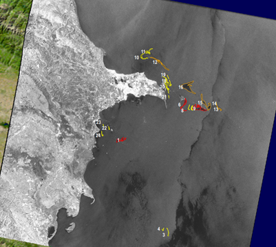
Surveillance is crucial in providing 'situational awareness' during an oil spill response operation. It is supported by a range of different technologies and techniques, from traditional and well-tested observation from vessels and aerial platforms to the use of innovative, small-scale uncrewed aerial vehicles. Satellite Remote Sensing (SRS) is an additional surveillance tool that can be readily used to provide synoptic and strategic information to the response. Remote sensing is the acquisition of data about an object or phenomenon without making physical contact with it, often using electromagnetic radiation.
For oil spill response, satellite imagery provides valuable information to inform effective decision-making by the Incident Management Team (IMT). The outputs can be added to a Common Operating Picture (COP) to aid in prioritising mission tasking for aerial surveillance and response operations.
RADARSAT-2
The Satellite Imagery service is part of our Service Level Agreement (SLA) and is available to all our members. Since 2016, the service has been provided by MacDonald, Dettwiler and Associates Ltd (MDA). MDA is a Canadian space technology company with international offices that provides geo-intelligence, robotics and satellite systems.
MDA provides our service with their RADARSAT-2 satellite, which uses C-band Synthetic-Aperture Radar (SAR). The satellite offers powerful technical advancements that enhance multiple applications including; marine surveillance, ice monitoring, disaster management, environmental monitoring, resource management, and mapping.
RADARSAT-2 is a satellite in a sun-synchronous orbit, completing 14.29 orbits of the earth per day, each orbit takes around 100 minutes with repeat orbit characteristics every 24 days.
This particular satellite can reach an altitude of 800km at a speed of 26,840 km/h which is the equivalent of travelling across the whole of Canada in ten minutes! It can take up to 60,000 images per year.
MDA also provides access to other satellites, which helps OSRL to improve the number of potential acquisitions for our members.
Advantages and Disadvantages
There are many advantages to using this technology. Here are some of them:
- Provides wide coverage area and outline of an anomaly (potential spill, assessed by probability of oil)
- Weather independent – not limited by darkness, cloud, fog, rain or smoke
- Proven use of technology, widely accepted by regulatory agencies
- GIS-ready products – Shapefiles that can be shown in a Common Operating Picture (COP)
- 24/7 Operations
There are also some disadvantages:
- Requires aerial surveillance to confirm and quantify oil
- Slick detection is best when wind speeds are between 3 m/s and 12 m/s
- Imagery must be interpreted by a skilled analyst (automation by Artificial Intelligence is coming)
- Images are prone to false positives (aerial surveillance must confirm if an anomaly is oil)
- Time – images not always available in a desired timeframe
Urban Myths
There are some urban myths about this technology that we can try to clear up:
“OSRL can position the satellites over a spill”.
That is not true. The satellite is in orbit, and we rely on being able to acquire images during an overpass of the Area of Interest (AOI) during the orbit. In the past 12 months, several members have requested information on the number of images that 'could be acquired' in a 24-day cycle. Here are some examples (coordinates of the AOI's have been redacted).
| RADARSAT-2 | Other Satellites | Total | |
| Angola | 8 | 2 | 10 |
| Egypt | 13 | 5 | 18 |
| North Sea | 22 | 8 | 30 |
| Senegal | 16 | 4 | 20 |
Outputs
MDA provide OSRL with:
- A detailed PDF analysis report
- KMZ (Google Earth)
- GIS-ready Shapefiles
- License Agreement

Image source: RADARSAT-2: Canadian Space Agency / Government of Canada
Enhance your response awareness and strategy development
Surveillance is an essential component in the development of a spill response strategy. In any spill event, situational awareness is vital for informing good decision-making.


